

Pilot Areas – Micro Level
Sakumono Basin (WP 1)
About 90.5 % of the population of the Greater Accra Region live in urban areas, which makes it the most urbanized region in Ghana1. Fast urbanization levels that are seen in all of Ghana’s cities lead to an increasing extent of impervious surfaces. Those are materials that prevent infiltration of water into soil, for example roads, rooftops, sidewalks and compacted soil. As a consequence, surface runoffs rise and discharge rates enlarge, overloading drainage channels and causing floods.2 In addition to that, a large proportion of inhabitants of densely populated cities like Accra live in informal settlements or slums1. Dwellers of such communities are living in very poor and vulnerable physical and socio-economic conditions, making them more prone to the impacts of flood disasters3. With regard to drought intensity, the Sakumono Basin is expected to experience high levels of drought in the future. However, being located in the Greater Accra Region, adaptive capacity is relatively high, which leads to a lower level of vulnerability towards droughts compared to other regions in Ghana.4 All these aspects lead to the urgent need for a resilient water management system to ensure sustainable water and food safety.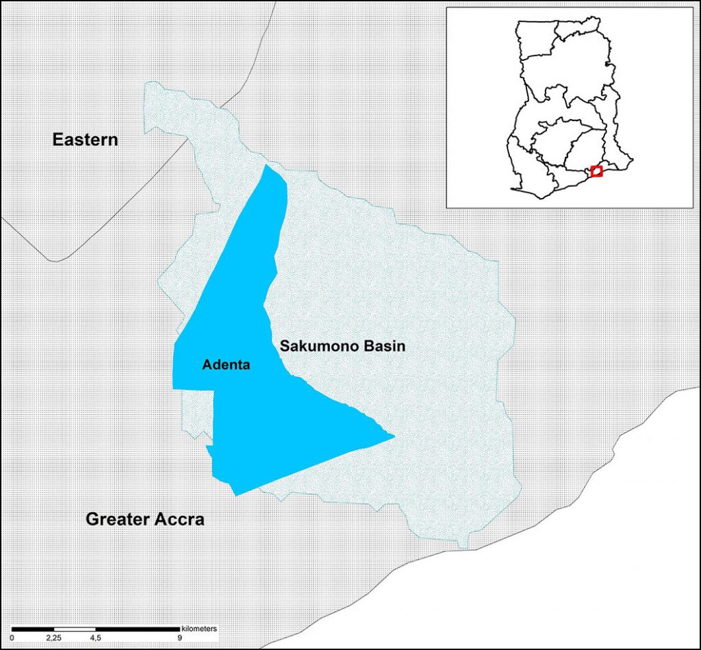
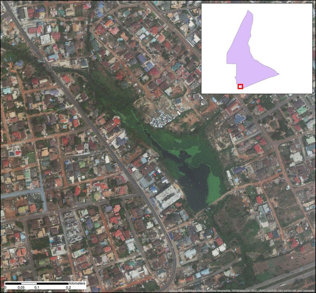
Water retention is an essential part of a sustainable water management strategy, especially when it comes to heavy rainfalls and dry periods. In the Adentan Municipal District this is achieved with 21 small water reservoirs, called ponds, some of which are temporary, others permanent. Dwellers living close by these ponds use the retained water either for agriculture or for domestic use, depending on the location of the pond. Data collection, sampling and surveys of the local population will help to understand the qualitative state of the retained water.
Nabogo Basin (WP 1)
The population of the Nabogo Basin depends heavily on agricultural activities as a source of occupation such as large scale livestock farming as well as production of rice, groundnut, yams, sorghum and cowpea. In addition, most of the fields are rain-fed, making these activities highly climate sensitive.6,7 Due to the semi-arid climate, water sources throughout the year are unreliable, and increasingly erratic rainfalls are intensifying this problem even further. Additionally, illiteracy levels in this zone are high, especially in rural areas. Illiterate populations are very limited in their capacity to access climate change information that can serve to empower them to take actions to cope, mitigate or adapt to the impacts of climate change. Thus, high illiteracy levels increase vulnerability to effects of climate change and variability. Another factor for the high vulnerability level of this region are less diversified sources of income. Especially rural dwellers tend to depend on a narrow range of income linked to one form of occupation. Subsistence farming is the main source of income for many households while only a few engage in other non-farm secondary jobs. Particularly in times of low crop production, this dependence comprises their livelihood security and negatively affects food production quantities, leaving people with a struggle to secure the welfare of their households.7 All these factors together put dwellers of the Nabogo Basin in a highly vulnerable position. Adaptation to the effect of climate change and variability therefore is substantially for this region.Within the scope of the project, drought and flood risk maps will be generated to built a base for the risk assessment and management concepts. Further, an end-to-end early warning system including a web-based application for the Nabogo Basin will be developed. Additionally, a water budget model will enable the long-term observation of the quantitative state of water resources in the course of 30 years. To include the assessment of needs, supplementary water management models will be developed for the Nabogo Basin. Lastly, a concept for the intelligent management of rainwater retention spaces to prevent floods in rural areas will be designed.
Sources:
1 Okyere, C.Y., Yacouba, Y., Gilgenbach, D. (2012): The Problem of Annual Occurrences of Floods in Accra: An Integration of Hydrological, Economic and Political Perspectives. Theoretical and Empirical Researches in Urban Management (8), p.45-79.
2 Ludwig, S. (2020): Beurteilung von Chancen und Grenzen der Modellanpassung am Beispiel eines Wasserhaushaltsmodells in Accra.
3 Amoako, C., Kweku Baah Inkoom, D. (2018): The Production of Flood Vulnerability in Accra, Ghana: Re-Thinking Flooding and Informal Urbanization. Urban Studies (55), p. 2903-2922.
4Antwi-Agyei, P. et al. (2012): Mapping the Vulnerability of Crop Production to Drought in Ghana Using Rainfall, Yield and Socioeconomic Data. Applied Geography (32), p. 324-334.
5 Ghana Statistical Service (2012): Population and Housing Census 2010.
6 Nsiah, E., Appiah-Adjei, E.K., Adjei, K.A. (2018): Hydrogeological Delineation of Groundwater Potential Zones in the Nabogo Basin, Ghana. Journal of African Earth Sciences (143), p. 1-9.
7 Dumenu, W.K., Obeng, E.A. (2016): Climate Change and Rural Communities in Ghana: Social Vulnerability, Impacts, Adaptations and Policy Implications. Environmental Science & Policy (55), p. 208-217.