

Pilot Areas – Macro Level
Hydrological Catchment Areas (WP 1)
In the course of the project two hydrological catchment areas were chosen, the Sakumono Basin and the Nabogo Basin. On the macro level, these two river basins will be the pilot regions to be studied, representing the two major issues the joint project RAIN is focusing on – drought and flood. An intelligent water management plan for both urban and rural areas to reduce the risk of flooding and drought through increased resilience is to be developed.
Sakumono Basin
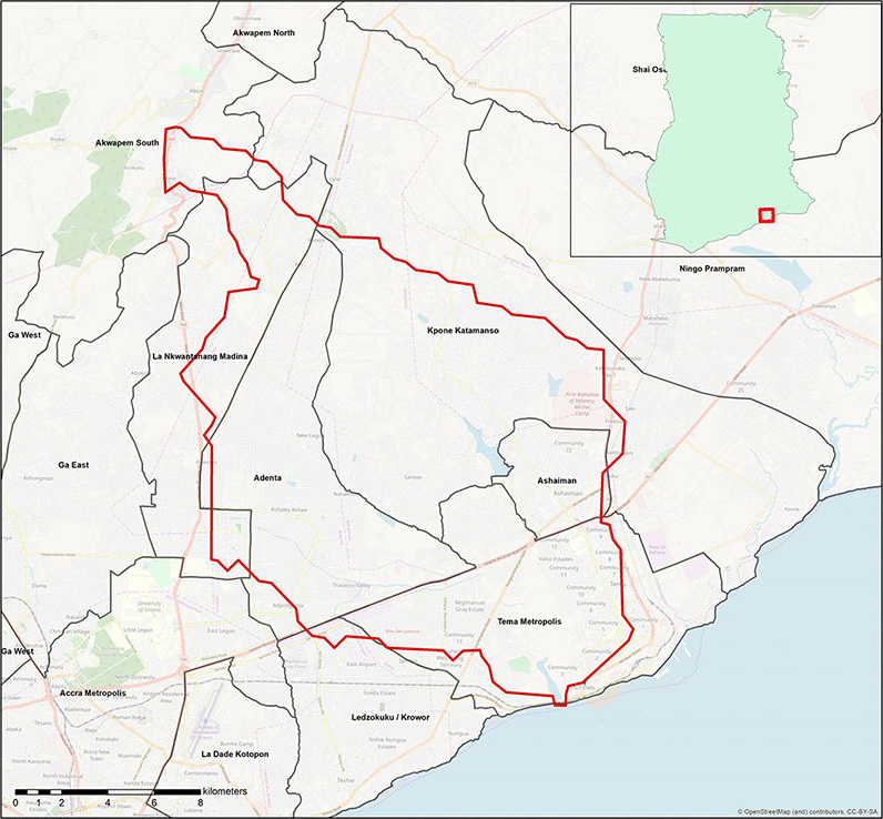
The Sakumono Basin is the hydrological catchment area of the Sakumono Lagoon, located east of Ghana’s capital Accra. This zone with a total area of 280 km2 spans between Accra and Tema and is predominantly urban, although there are a few semi-urban regions1. The main urban areas consist of the Adentan Municipal District, the city Ashaiman and parts of the city Tema. According to the last census in 2010 these three regions alone had over 600.000 inhabitants2. The nothern part of the basin is less densely populated, with woodland and fields between the residential areas.Climatic Conditions
The climate of the Sakumono Basin is semi-arid with rainy seasons from Mai to July and from September to October. Because of the climatic conditions this region experiences both floods and droughts. Especially during rainy season, sudden and heavy rainfalls that lead to flooding events are usual. Additionally the annual rainfall can be inconsistant. While the mean annual precipitation is of 805 mm, some years can be extremely dry with rainfalls of 330 mm/year and some can be very wet with up to 1650 mm/year. The average monthly temperature reaches from 24.7°C in August to 33°C in March, with an annual average of 26°C. Subsequently, these high temperatures can cause drought periods.1 All these factors make the Sakumono Basin an interesting challenge for water management questions.Sakumono Basin
The Sakumono Basin is the hydrological catchment area of the Sakumono Lagoon, located east of Ghana’s capital Accra. This zone with a total area of 280 km2 spans between Accra and Tema and is predominantly urban, although there are a few semi-urban regions1. The main urban areas consist of the Adentan Municipal District, the city Ashaiman and parts of the city Tema. According to the last census in 2010 these three regions alone had over 600.000 inhabitants2. The nothern part of the basin is less densely populated, with woodland and fields between the residential areas.
Ghana – History of Droughts and Floods
Historically, floods represent Ghana’s biggest threat in terms of lives affected by natural disasters. Over the past 40 years, floods, mostly related to river floods (primarily in the Volta River System) and in urban areas, have affected nearly four million people in Ghana.3 During the period from 1968 to 2011, nine out of ten of the worst catastrophes were floods, the 10th being a drought. About 3.81 million people were affected and 298 killed by flooding events in this timespan.4 A flood in 2007 displaced not only about 332,000 people, but also destroyed over 500 km of road and other infrastructure. The greatest impact was felt in the three northern regions of Upper East, Upper West and Northern Region due to extensive flooding of the Volta River, making it one of the most severe floods in the country.3,4 Another flooding event took place in the Volta, Central, Western, Eastern and Greater Accra Regions in June 2010, affecting about 33,000 lives and displacing up to 15,000, again causing major infrastructural damage.4
Continuing droughts pose a major threat for countries in the West African Sahel, including Ghana, as well. Notable years of drought with areal extents of 50 % or more were 1961, 1970, 1983, 1992 and 2001. In terms of lives affected, the drought of 1983 is the most severe disaster in Ghana’s recent history. Moreover, in the early 1970s Ghana and other West African countries suffered a series of drought years, which had devastating consequences for the population of the whole region. In addition to these years of recurrent drought, high variability in the monsoon rains and increasing unpredictability of erratic rainfalls heavily affected crop production, provoking structural food shortages and hunger.5

Nabogo Basin
The Nabogo Basin is a rural area located 40 km from Tamale in the Northern Region of Ghana. The sub-basin of the White Volta Basin drains an area of about 2900 km2.6 It overlaps parts of the districts Savelugu Nanton, Karaga and Gushiegu, which together have a total population of over 300.000 inhabitants.2Climatic conditions
The Nabogo Basin is characterized by an arid to semi-arid environment and has a unimodal rainy season that starts in May, reaches its climax in July/August and diminishes in October with an otherwise dry climate. The mean annual rainfall is estimated to be 1083 mm/year. However, daily temperatures in the Northern Region are quite high, reaching from above 35°C to below 20°C.6 This area is therefore much more affected by droughts than the Greater Accra Region. The drought risk for Ghana is generally expected to increase in the future, resulting in a high risk for the Northern Region. To make this area more resistant to its current and changing climate, an intelligent water management plan is crucial.Sources:
1 Ludwig, S. (2020): Beurteilung von Chancen und Grenzen der Modellanpassung am Beispiel eines Wasserhaushaltsmodells in Accra.
2 Ghana Statistical Service (2012): Population and Housing Census 2010.
3 World Bank (2017): Enhancing Urban Resilience in the Greater Accra Metropolitan Area. Washington, D.C. © World Bank.
4 Okyere, C.Y., Yacouba, Y., Gilgenbach, D. (2012): The Problem of Annual Occurrences of Floods in Accra: An Integration of Hydrological, Economic and Political Perspectives. Theoretical and Empirical Researches in Urban Management (8), p. 45-79.
5 Kasei, R., Diekkrüger, B., Leemhuis, C. (2010): Drought Frequency in the Volta Basin of West Africa. Sustainability Science (5), p. 89.
6 Nsiah, E., Appiah-Abjei, E.K., Abjei, K.A. (2018): Hydrogeological Delineation of Groundwater Potential Zones in the Nabogo Basin, Ghana. Journal of African Earth Science (143), p. 1-9.